GIS and Data Collection

GIS – The Data Platform

GIS integrates and overlay unlimited layers of themed spatial and tabular data to illustrate and reveal patterns, context, and the intrinsic qualities of any location.

Leveraging GIS for Environmental, Natural Resource, and Land Use Planning is our core expertise.  GIS is a powerful analysis tool capable of querying data for location and its relationship to overall context.  At TGA, we have an intimate understanding of these tools and their capabilities.

Working with you and other experts, we build a completely defensible, dynamic analysis data platform with interactive visualizations and related tables that clearly represent the qualities of your project and its relationship to larger political, environmental, and regional contexts.


Data Collection: Real World Verification with GPS

GPS pins the abstract to defensible and auditable real-world coordinates and geography.

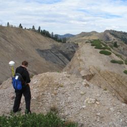
TGA performs field data acquisition with mapping-grade GPS equipment to obtain independent reference data and verify the accuracy of information found on paper or digital maps. It also allows for the capture of previously unmapped features including boundaries, buildings, vegetation, water bodies, and other critical information related to your project.

Depending on accuracy requirements, TGA will use Trimble mapping grade units for sub-meter accuracy or customized MapToTrack™ apps on iPhones/Pads and Android devices, enhanced with an external GPS receiver that fits in a pocket, for 1m accuracy.

GPS fieldwork
Copyright 2017 | Temporal Geo Analytics Inc.| All Rights Reserved